Constructing Isolated Towns and Zip Code Information
Allan Collard-Wexler
Isolated Towns
I choose my markets to be the area around towns in the
Continental United States. I get the data on places in the
First, I need to drop places in my dataset below a certain
population threshold. In the Continental
Second, I need to check if a town is isolated. To do this I
have coded a routine in Arcview© which counts the number of towns located
within a specific distance from the central place. On average, a place in the
Table 1: Number of Isolated Towns
|
No neighboring
cities of a least 2000 inhabitants within |
Number of Cities |
|
20 miles |
449 |
|
30 miles |
194 |
|
40 miles |
102 |

Figure 1:
Several towns are adjacent to each other. An analogy to this
situation (while of course not itself an isolated town!) is the
Minneapolis-Saint Paul MSA, which is composed of two adjacent cities:
|
Isolated Cities and Adjacent Towns |
|
|
|
374 |
|
|
75 |

Figure 2: Single Agglomeration composed of many places
Zip Codes
To make this data set more useful to researchers, I also select zip codes within a certain distance of the isolated towns. Zip codes can be used, for instance, to count the number of establishments within 5 miles of the central place, since ready-mix concrete plants frequently locate outside the boundaries of the municipality, and thus will not be part of the municipality proper, but will belong to a zip code located within a small distance from the central town. Again, the data on zip codes come from the U.S. Census Bureau. I include all zip codes within 5, 10 and 20 miles of an isolated town.
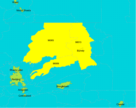
Figure 3: Zip Codes within 5 miles of
Code Book
|
|
|
|
|
variable
name |
storage type |
variable
label |
|
|
|
|
|
areaname |
str25 |
Place
Name |
|
class |
str18 |
Place
Type |
|
st |
str2 |
State |
|
stfips |
str2 |
State
FIPS |
|
placefip |
str5 |
Place FIPS |
|
houseunits |
long |
Number of
Housing units in |
|
|
|
Place in
1990 |
|
population |
long |
Population
of Place in 2000 |
|
pop_cl |
byte |
Place
Population Class |
|
arealand |
float |
Land Area
of Place |
|
areawater |
float |
Water
Area of Place |
|
nbr1 |
byte |
Cities
with more than 2000 |
|
|
|
inhabitants
within 1 mile (including place itself) |
|
nbr20 |
byte |
Cities
with more than 2000 |
|
|
|
inhabitants
within 20 miles |
|
nbr30 |
byte |
Cities
with more than 2000 |
|
|
|
inhabitants
within 30 miles |
|
nbr40 |
byte |
Cities
with more than 2000 |
|
|
|
inhabitants
within 40 miles |
|
autoroute |
byte |
Highway
within 5 miles of place |
|
population1 |
long |
Population
in 1990 |
|
vacant |
long |
Number of
Vacant Houses |
|
housing |
long |
Number of
Houses |
|
zipcode5mx |
long |
Zip Code
within 5 miles of |
|
|
|
place
number x |
|
zipcode10mx |
long |
Zip Code within
10 miles of |
|
|
|
place
number x |
|
zipcode20mx |
long |
Zip Code
within 20 miles of |
|
|
|
place
number x |
Arcview Code for finding the number of neighbors for an
isolated town
'
This script selects all cities which are located far away from other cities
' Get the FTabs...
cities=
av.GetProject.FindDoc("View1").FindTheme("placeply.shp").GetFtab
'Clone the cities Note that over2000 was
created to select only cities with more than 2000 people
cities2=cities.clone
cities3=cities.clone
' 20 miles
distance = Units.Convert( 20,
#UNITS_LINEAR_MILES, #UNITS_LINEAR_DEGREES )
close = Units.Convert( 1, #UNITS_LINEAR_MILES,
#UNITS_LINEAR_DEGREES )
' Select population cutoff say 2 000
expr="[population]>2000"
cities.GetSelection.ClearAll
cities.Query(expr,cities.GetSelection,#VTAB_SELTYPE_NEW)
'start loop
for each rec in cities.GetSelection.clone
' Select cites within 20 miles of selected
cities
cities2.GetSelection.ClearAll
cities2.GetSelection.Set(rec)
cities3.SelectByFTab( cities2,
#FTAB_RELTYPE_ISWITHINDISTANCEOF,distance, #VTAB_SELTYPE_NEW )
allneighbours=cities3.GetNumSelRecords
' Count cities which are within a close
distance to the major city which will include the city itself
cities3.SelectByFTab( cities2,
#FTAB_RELTYPE_ISWITHINDISTANCEOF,close, #VTAB_SELTYPE_AND )
nearneighbours=cities3.GetNumSelRecords
'Record number of cities within area
cities.SetValue(cities.FindField("Nbr20"),rec,allneighbours-nearneighbours)
end